Satellite Observation for Aquaculture: Bangladesh
- 29 March 2019
- Category: News, References
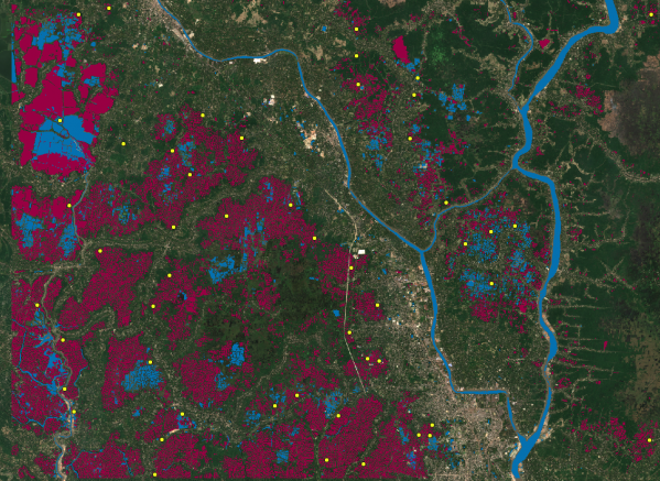
(Image from ESA-Sentinel-2. Contains modified Copernicus Sentinel data [2018])
Earth Observation for Aquaculture Inventories: Bangladesh
In the south-western region of Bangladesh, aquaculture plays a significant role in food production and is crucial to local economies. A few decades ago most of the lands in this region were used for agriculture, especially for paddy cultivation using rain as well as river water. Land use has evolved due to climate change and geophysical changes (e.g. siltation problem) in the main river systems. Farmers have had to adapt their livelihoods, by transforming the seasonally flooded paddy fields into aquaculture ponds. Most of the aquaculture farms in this area are involved in farming brackish and freshwater species with large export potential. Regional authorities, backed by international organizations, want to ensure their sustainability, but field studies would be too costly and time-consuming. A new study carried out by CLS shows that Earth observation data from European satellites can provide key information about Bangladesh’s artisanal aquaculture industry.
Assessing the Environmental Impact of Aquaculture
The UN FAO (Food and Agriculture Organization) assists countries in recording the location and type of aquaculture facilities so they can improve their aquaculture zoning, site selection and area management. In a project funded by NACA (Network of Aquaculture Centres in Asia-Pacific) and backed by the Blue Growth Initiative (BGI) and FAO-Department of Fisheries and in collaboration with World Fish (WF), CLS was commissioned to study how satellite imagery can help regional authorities assess the environmental impacts of aquaculture in Bangladesh. This innovative project combined high resolution satellite imagery with field visits to locate aquaculture hotspots and characterize their lifecycle.
The project builds on a method that was developed within the H2020 BlueBridge project, to promote the use of Earth Observation data for aquaculture inventories. The method was adapted to the specific case of south-west Bangladesh, where two types of aquaculture structures co-exist: permanently flooded ponds for aquaculture and “gher” systems which alternate between aquaculture and rice fields depending on the season.
Why Satellite Imagery is Crucial
Time-series of optical satellite images were crucial to the seasonal classification of land use in this project due to the large spatial area covered (625 km²) and its remoteness. Sentinel-2 images are currently the most interesting open database of optical satellite imagery over the area with a 10-meter spatial resolution (10 meters) and 5-day revisit.
The study was limited to a selected area located in the southern districts of Bangladesh. Ponds and “ghers” were first identified automatically, after applying Normalized Difference Water Index (NDWI) filter on Sentinel-2 images. The automatic detection results were then validated and refined by human experts at CLS’s subsidiary, SIRS (https://www.sirs-fr.com/sirs/en/). The CLS study made it possible to delineate zones where aquaculture was suspected and within these zones, identify 50 spots of interest where field verification was performed.
The 50 sites of interest were visited and analyzed by a field team of the Khulna University led by Prof. Dr. Khandaker Anisul Huq to validate the automatic aquaculture facilities detection method.
45 of the 50 hotspots were correctly classified with the method developed by CLS.
The study shows that EO data and the method developed within the H2020 BlueBridge (https://www.bluebridge-vres.eu/ ) project can be adapted to assess Bangladesh aquaculture infrastructures and provide an up-to-date aquaculture inventory to be used as a baseline information for the planning and management of aquaculture in these areas. In addition, CLS made a series of recommendations to enhance the results, by adding additional satellite observations into the automatic detection algorithms in future projects with additional budget allocation
Project objectives
- Provide a method for performing inventories and monitoring of aquaculture facilities with EO data
- Provide decision-makers with important baseline data and trends on production,
- Provide area boundaries, size distribution of farms, environmental conditions and impacts, spatial risks (to the ecosystem and to the farming systems)
- Provide data to increase production, improve emergency preparedness (including for diseases) and reduce risks in general
- Evaluate the impact of climate change on the aquaculture ecosystem.
Time period: Between November 2017 and May 2018
- 18: Number of Sentinel-2 images studied within the project
- 625 : Number of km² analyzed within the study
- 50: Number of interviews with local farmers:
- 25,000 : Number of aquaculture structures detected over the area of interest
- 9.5 million: Number of people (73 percent of population) involved in subsistence fisheries on the country’s flood plains